Thank you for supporting this site ❤️
Make a donation
Make a donation
Gear up for your next adventure:
As an Amazon Associate, this site earns from qualifying purchases at no extra cost to you.
Canal Run
Afternoon Run
- Distance: 3.0 mi
- Elevation gain: 6 m
- Maximum elevation: 40 m
- Elevation loss: 6 m
- Minimum elevation: 37 m
- Moving time: 34 m 28 s
- Moving speed: 5.2 mph
- Maximum speed: 11.8 mph
- Total time: 36 m 42 s
- Global speed: 4.9 mph
Interactive trail map
Thank you for supporting this site ❤️
Make a donation
Make a donation
Gear up for your next adventure:
As an Amazon Associate, this site earns from qualifying purchases at no extra cost to you.
Trail profile
- Distance: 3.0 mi
- Elevation gain: 6 m
- Maximum elevation: 40 m
- Elevation loss: 6 m
- Minimum elevation: 37 m
- Moving time: 34 m 28 s
- Moving speed: 5.2 mph
- Maximum speed: 11.8 mph
- Total time: 36 m 42 s
- Global speed: 4.9 mph
Thank you for supporting this site ❤️
Make a donation
Make a donation
Gear up for your next adventure:
As an Amazon Associate, this site earns from qualifying purchases at no extra cost to you.
About this trail
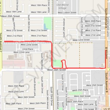
Name: Canal Run trail, distance, elevation, map, profile, GPS track
Start: Yuma, Yuma County, Arizona, 85364, United States (32.68762 -114.66686)
End: Yuma, Yuma County, Arizona, 85364, United States (32.68768 -114.66679)
Coordinates: 32.68400 -114.66686 32.68770 -114.65052
Thank you for supporting this site ❤️
Make a donation
Make a donation
Gear up for your next adventure:
As an Amazon Associate, this site earns from qualifying purchases at no extra cost to you.