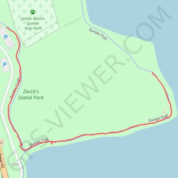
Zwick's Island Park
- Distance: 0.5 mi
- Elevation gain: 5 m
- Maximum elevation: 81 m
- Elevation loss: 3 m
- Minimum elevation: 76 m
- Moving time: 15 m 45 s
- Moving speed: 2.1 mph
- Maximum speed: 4.0 mph
- Total time: 15 m 45 s
- Global speed: 2.1 mph
Interactive trail map
Trail profile
- Distance: 0.5 mi
- Elevation gain: 5 m
- Maximum elevation: 81 m
- Elevation loss: 3 m
- Minimum elevation: 76 m
- Moving time: 15 m 45 s
- Moving speed: 2.1 mph
- Maximum speed: 4.0 mph
- Total time: 15 m 45 s
- Global speed: 2.1 mph
About this trail
Name: Zwick's Island Park trail, distance, elevation, map, profile, GPS track
Start: Gunpo Trail, Belleville, Central Ontario, Ontario, K8N 1B5, Canada (44.15355 -77.38325)
End: Jack Ellis Trail, Belleville, Central Ontario, Ontario, K8N 1B5, Canada (44.15456 -77.38784)
Coordinates: 44.15177 -77.38784 44.15456 -77.38264
Other hiking, mountain biking, running and outdoor activity trails
Click on a trail to view its statistics, map and profile.
Belleville - Kingston
Canada > Ontario > Belleville > Belleville
#Bike
Distance: 57.6 mi • Elevation gain: 394 m • Maximum elevation: 115 m
Cobourg - Belleville
Canada > Ontario > Northumberland County > Cobourg
#Bike
Distance: 50.6 mi • Elevation gain: 286 m • Maximum elevation: 118 m