Make a donation
Gear up for your next adventure:
As an Amazon Associate, this site earns from qualifying purchases at no extra cost to you.
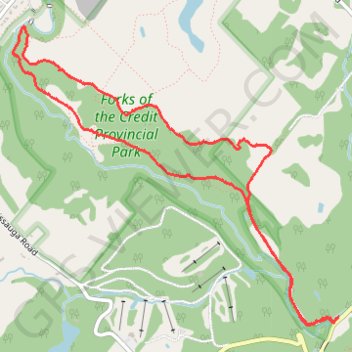
Bruce Trail Loop
Forks of the Credit Provincial Park. #Hiking #Snowshoeing #ForksOfTheCredit
- Distance: 4.8 mi
- Elevation gain: 172 m
- Maximum elevation: 404 m
- Elevation loss: 172 m
- Minimum elevation: 308 m
Interactive trail map
Make a donation
Gear up for your next adventure:
As an Amazon Associate, this site earns from qualifying purchases at no extra cost to you.
Trail profile
- Distance: 4.8 mi
- Elevation gain: 172 m
- Maximum elevation: 404 m
- Elevation loss: 172 m
- Minimum elevation: 308 m
Make a donation
Gear up for your next adventure:
As an Amazon Associate, this site earns from qualifying purchases at no extra cost to you.
About this trail
Name: Bruce Trail Loop trail, distance, elevation, map, profile, GPS track
Coordinates: 43.80263 -80.02262 43.82154 -79.99403
Make a donation
Gear up for your next adventure:
As an Amazon Associate, this site earns from qualifying purchases at no extra cost to you.
Other hiking, mountain biking, running and outdoor activity trails
Click on a trail to view its statistics, map and profile.
Orangeville - Brampton
Canada > Ontario > Dufferin County > Mono
Distance: 34.1 mi • Elevation gain: 206 m • Maximum elevation: 461 m
Ontario country roads
Distance: 93.4 mi • Elevation gain: 1,137 m • Maximum elevation: 497 m
Make a donation
Gear up for your next adventure:
As an Amazon Associate, this site earns from qualifying purchases at no extra cost to you.