Make a donation
Gear up for your next adventure:
As an Amazon Associate, this site earns from qualifying purchases at no extra cost to you.
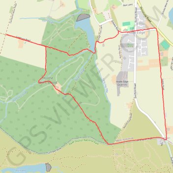
From Hade Edge
Hade Edge - Boshaw Whams Reservoir - Harden - Peak District National Park - Holme Styes Reservoir
- Distance: 3.8 mi
- Elevation gain: 166 m
- Maximum elevation: 398 m
- Elevation loss: 166 m
- Minimum elevation: 276 m
- Moving time: 1 h 59 m
- Moving speed: 1.9 mph
- Maximum speed: 3.5 mph
- Total time: 2 h 56 m
- Global speed: 1.3 mph
Interactive trail map
Make a donation
Gear up for your next adventure:
As an Amazon Associate, this site earns from qualifying purchases at no extra cost to you.
Trail profile
- Distance: 3.8 mi
- Elevation gain: 166 m
- Maximum elevation: 398 m
- Elevation loss: 166 m
- Minimum elevation: 276 m
- Moving time: 1 h 59 m
- Moving speed: 1.9 mph
- Maximum speed: 3.5 mph
- Total time: 2 h 56 m
- Global speed: 1.3 mph
Make a donation
Gear up for your next adventure:
As an Amazon Associate, this site earns from qualifying purchases at no extra cost to you.
About this trail
Name: From Hade Edge trail, distance, elevation, map, profile, GPS track
Coordinates: 53.53475 -1.80293 53.54657 -1.77567
Topography: Kirklees topographic map, elevation, terrain
Make a donation
Gear up for your next adventure:
As an Amazon Associate, this site earns from qualifying purchases at no extra cost to you.
Other hiking, mountain biking, running and outdoor activity trails
Click on a trail to view its statistics, map and profile.
Cartworth Moor Loop
United Kingdom > England > Kirklees > Holmfirth > Washpit Mill
Distance: 3.5 mi • Elevation gain: 157 m • Maximum elevation: 346 m