Thank you for supporting this site ❤️
Make a donation
Make a donation
Gear up for your next adventure:
As an Amazon Associate, this site earns from qualifying purchases at no extra cost to you.
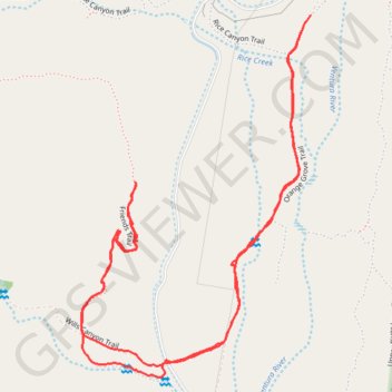
Friends, Wills Canyon
Ventura River Preserve
- Distance: 2.3 mi
- Elevation gain: 64 m
- Maximum elevation: 258 m
- Elevation loss: 64 m
- Minimum elevation: 214 m
- Moving time: 58 m 29 s
- Moving speed: 2.4 mph
- Maximum speed: 4.5 mph
- Total time: 1 h 4 m
- Global speed: 2.1 mph
Interactive trail map
Thank you for supporting this site ❤️
Make a donation
Make a donation
Gear up for your next adventure:
As an Amazon Associate, this site earns from qualifying purchases at no extra cost to you.
Trail profile
- Distance: 2.3 mi
- Elevation gain: 64 m
- Maximum elevation: 258 m
- Elevation loss: 64 m
- Minimum elevation: 214 m
- Moving time: 58 m 29 s
- Moving speed: 2.4 mph
- Maximum speed: 4.5 mph
- Total time: 1 h 4 m
- Global speed: 2.1 mph
Thank you for supporting this site ❤️
Make a donation
Make a donation
Gear up for your next adventure:
As an Amazon Associate, this site earns from qualifying purchases at no extra cost to you.
About this trail
Name: Friends, Wills Canyon trail, distance, elevation, map, profile, GPS track
Start: Orange Grove Trail, Ventura County, California, 93023, United States (34.45803 -119.29313)
End: Orange Grove Trail, Ventura County, California, 93023, United States (34.45839 -119.29286)
Coordinates: 34.45038 -119.29901 34.45839 -119.29286
Thank you for supporting this site ❤️
Make a donation
Make a donation
Gear up for your next adventure:
As an Amazon Associate, this site earns from qualifying purchases at no extra cost to you.