Import a GPX file

Skull Rock and Temescal Falls Loop in Topanga State Park

The Skull Rock and Temescal Falls Loop in Topanga State Park offers hikers a diverse experience, featuring lush shaded trails, exposed steep climbs, and gorgeous ocean views. Along the route, you'll encounter the intriguing Skull Rock formation, which resembles a skull, and a small cascade known as Temescal Falls. The trail also provides panoramic vistas of the Pacific Ocean and the surrounding Santa Monica Mountains, making it a rewarding adventure for those seeking both natural beauty and a solid workout. #Hiking #Mountain #Forest #Nature #Loop #Rock #Waterfall #Pacific #Ocean #Sea #Overlook
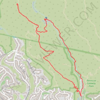
  • Distance: 4.2 mi
  • Elevation gain: 335 m
  • Maximum elevation: 427 m
  • Elevation loss: 335 m
  • Minimum elevation: 107 m
  • Moving time: 1 h 16 m
  • Moving speed: 3.3 mph
  • Maximum speed: 6.4 mph
  • Total time: 1 h 18 m
  • Global speed: 3.2 mph

Interactive trail map

Trail profile

  • Distance: 4.2 mi
  • Elevation gain: 335 m
  • Maximum elevation: 427 m
  • Elevation loss: 335 m
  • Minimum elevation: 107 m
  • Moving time: 1 h 16 m
  • Moving speed: 3.3 mph
  • Maximum speed: 6.4 mph
  • Total time: 1 h 18 m
  • Global speed: 3.2 mph

About this trail

Name: Skull Rock and Temescal Falls Loop in Topanga State Park trail, distance, elevation, map, profile, GPS track

Start: Temescal Canyon Road, Pacific Palisades, Los Angeles, Los Angeles County, California, 90272, United States (34.05383 -118.52877)

End: Temescal Canyon Road, Pacific Palisades, Los Angeles, Los Angeles County, California, 90272, United States (34.05380 -118.52871)

Coordinates: 34.05380 -118.54303 34.07084 -118.52824

Other hiking, mountain biking, running and outdoor activity trails

Click on a trail to view its statistics, map and profile.

Playa Vista to Topanga State Park

United States > California > Los Angeles County > Los Angeles

Mountain Bike via Venice Beach, Santa Monica State Beach, Will Rogers State Beach and East Topanga Fire Road in Santa Monica National Mountains Recreation Area. #MTB #Beach #Mountain #Sea #Pacific #Ocean #City #Nature

Distance: 29.3 mi • Elevation gain: 589 m • Maximum elevation: 340 m

Skull Rock and Temescal Falls Loop

United States > California > Los Angeles County > Los Angeles

Loop hike to Skull Rock and Temescal Falls via Temescal Ridge Trail and Temescal Canyon Trail in Topanga State Park #Hiking #Mountain #Forest #Loop #Rock #Waterfall #Ocean

Distance: 4.1 mi • Elevation gain: 339 m • Maximum elevation: 427 m

Temescal Falls Loop via Temescal Canyon

United States > California > Los Angeles County > Los Angeles

Topanga State Park. #Hiking #Running #Loop #Canyon #Waterfall #River #Forest #Nature #Topanga

Distance: 2.9 mi • Elevation gain: 245 m • Maximum elevation: 348 m

Temescal Falls

United States > California > Los Angeles County > Los Angeles

Loop hike from Pacific Palisades to Temescal Falls on the Temescal Canyon Trail in the Topanga State Park. #Hiking #Loop #Falls #River #Forest #Mountain #Park #Pacific #Ocean

Distance: 3.2 mi • Elevation gain: 284 m • Maximum elevation: 347 m

Gear up for your next adventure:

🔦Head Torches - Hands-free lighting for hiking and camping
🖼️Topographic Map Art - Decorative 3D-effect posters of famous UK peaks and regions
👟Waterproof Leg Gaiters - Keep mud and water out of your boots in boggy terrain
🥤Collapsible Water Bottles - Save space in your rucksack as you consume your water
🗺️Ordnance Survey Maps - Essential paper maps for hiking across the UK national parks

As an Amazon Associate, this site earns from qualifying purchases at no extra cost to you.