Thank you for supporting this site ❤️
Make a donation
Make a donation
Gear up for your next adventure:
As an Amazon Associate, this site earns from qualifying purchases at no extra cost to you.
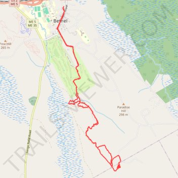
Bethel MTB Trails
- Distance: 7.3 mi
- Elevation gain: 175 m
- Maximum elevation: 325 m
- Elevation loss: 175 m
- Minimum elevation: 208 m
- Moving time: 1 h 13 m
- Moving speed: 6.0 mph
- Maximum speed: 22.8 mph
- Total time: 1 h 23 m
- Global speed: 5.2 mph
Interactive trail map
Thank you for supporting this site ❤️
Make a donation
Make a donation
Gear up for your next adventure:
As an Amazon Associate, this site earns from qualifying purchases at no extra cost to you.
Trail profile
- Distance: 7.3 mi
- Elevation gain: 175 m
- Maximum elevation: 325 m
- Elevation loss: 175 m
- Minimum elevation: 208 m
- Moving time: 1 h 13 m
- Moving speed: 6.0 mph
- Maximum speed: 22.8 mph
- Total time: 1 h 23 m
- Global speed: 5.2 mph
Thank you for supporting this site ❤️
Make a donation
Make a donation
Gear up for your next adventure:
As an Amazon Associate, this site earns from qualifying purchases at no extra cost to you.
About this trail
Name: Bethel MTB Trails trail, distance, elevation, map, profile, GPS track
Start: 7, Mechanic Street, Bethel, Oxford County, Maine, 04217, United States (44.40873 -70.78913)
End: 7, Mechanic Street, Bethel, Oxford County, Maine, 04217, United States (44.40870 -70.78905)
Coordinates: 44.37611 -70.79097 44.40873 -70.77322
Thank you for supporting this site ❤️
Make a donation
Make a donation
Gear up for your next adventure:
As an Amazon Associate, this site earns from qualifying purchases at no extra cost to you.