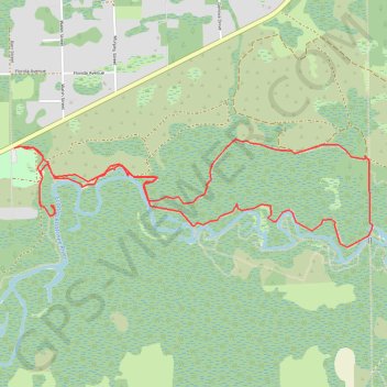
Little Big Econ State Forest Loop
This loop enters Little Big Econ State Forest on the Barr Street Trail, then follows the Florida Trail through humid subtropical woodland toward the Econlockhatchee River.
The route continues beside the river corridor, where sandy banks, low bluffs, floodplain forest, and quiet wetland views shape the main character of the hike.
It then turns back by way of the Flagler Trail and Kolokee Trail, linking former rail-grade terrain, pine flatwoods, and shaded forest paths before returning to Barr Street.
#Hiking #Loop #Forest #Nature #River
- Distance: 5.8 mi
- Elevation gain: 15 m
- Maximum elevation: 11 m
- Elevation loss: 15 m
- Minimum elevation: 5 m
- Moving time: 3 h 24 m
- Moving speed: 1.7 mph
- Maximum speed: 3.0 mph
- Total time: 4 h 3 m
- Global speed: 1.4 mph
Interactive trail map
Trail profile
- Distance: 5.8 mi
- Elevation gain: 15 m
- Maximum elevation: 11 m
- Elevation loss: 15 m
- Minimum elevation: 5 m
- Moving time: 3 h 24 m
- Moving speed: 1.7 mph
- Maximum speed: 3.0 mph
- Total time: 4 h 3 m
- Global speed: 1.4 mph
About this trail
Name: Little Big Econ State Forest Loop trail, distance, elevation, map, profile, GPS track
Start: Barr Street Trailhead Parking, CR 426, Seminole County, Florida, United States (28.68733 -81.15933)
End: Barr Street TH Approach, Seminole County, Florida, United States (28.68745 -81.15905)
Coordinates: 28.68053 -81.15933 28.68792 -81.13146
Other hiking, mountain biking, running and outdoor activity trails
Click on a trail to view its statistics, map and profile.
Florida Trail from Lockwood Road to Barr Street in Little Big Econ State Forest
United States > Florida > Seminole County > Oviedo
This Florida Trail section offers a tranquil and diverse hiking experience. Hikers will encounter boardwalks crossing small creeks, as well as sections that skirt the serene shores of the Econlockhatchee River, providing scenic views of the surrounding cypress trees and oak hammocks. The trail offers a…
Distance: 5.8 mi • Elevation gain: 19 m • Maximum elevation: 14 m
Florida Trail and Kolokee Trail Loop in Little Big Econ State Forest
United States > Florida > Seminole County
This loop offers a serene escape into nature with scenic views of the Econlockhatchee River and lush, subtropical forest landscapes. Hikers will encounter a variety of wildlife, including the chance to spot alligators along the riverbanks, as well as peaceful forest environments dotted with marshes and creeks.…
Distance: 5.2 mi • Elevation gain: 14 m • Maximum elevation: 11 m