Import a GPX file

Saint Arnaud - Murchison

Lake Rotoiti, Lake Rotoroa, Buller River, Gowan River, Mangles River. #Bike #Road #Lake #River #Mountain #Forest #Nature

  • Distance: 45.2 mi
  • Elevation gain: 712 m
  • Maximum elevation: 661 m
  • Elevation loss: 1,166 m
  • Minimum elevation: 172 m

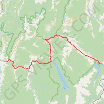
Interactive trail map

Trail profile

  • Distance: 45.2 mi
  • Elevation gain: 712 m
  • Maximum elevation: 661 m
  • Elevation loss: 1,166 m
  • Minimum elevation: 172 m

About this trail

Name: Saint Arnaud - Murchison trail, distance, elevation, map, profile, GPS track

Start: Kerr Bay Campsite, Lake Road, Saint Arnaud, 7053, New Zealand (-41.80587 172.84745)

End: Riverview Holiday Park, Riverview Road, Murchison, 7007, New Zealand (-41.79590 172.34090)

Coordinates: -41.82681 172.34023 -41.69414 172.84745

Other hiking, mountain biking, running and outdoor activity trails

Click on a trail to view its statistics, map and profile.

Tour Te Waipounamu

New Zealand > Tasman > Tasman District > Port Pūponga

Bikepacking race through the South Island of New Zealand. #Bike #Race #Island #Sea #Pacific #Ocean #Nature #Mountain #Forest #Countryside

Distance: 820.8 mi • Elevation gain: 23,362 m • Maximum elevation: 1,946 m

Murchison - Reefton

New Zealand > Murchison

#Bike

Distance: 75.9 mi • Elevation gain: 1,826 m • Maximum elevation: 689 m

Gear up for your next adventure:

📦Dry Bags - Waterproof bags to protect gear from rain
🥤Collapsible Water Bottles - Save space in your rucksack as you consume your water
🧺Microfibre Travel Towels - Fast-drying and compact towels for wild swimming and camping
🐕Hiking Dog Harnesses - Rugged harnesses for taking your companion on mountain trails
🥼Base Layers - Thermal base layers for temperature regulation

As an Amazon Associate, this site earns from qualifying purchases at no extra cost to you.