Make a donation
Gear up for your next adventure:
As an Amazon Associate, this site earns from qualifying purchases at no extra cost to you.
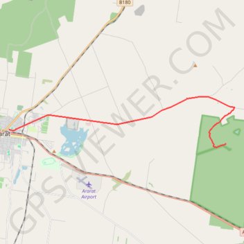
Ararat - Langi Ghiran State Park
#Bike
- Distance: 11.9 mi
- Elevation gain: 211 m
- Maximum elevation: 431 m
- Elevation loss: 112 m
- Minimum elevation: 299 m
Interactive trail map
Make a donation
Gear up for your next adventure:
As an Amazon Associate, this site earns from qualifying purchases at no extra cost to you.
Trail profile
- Distance: 11.9 mi
- Elevation gain: 211 m
- Maximum elevation: 431 m
- Elevation loss: 112 m
- Minimum elevation: 299 m
Make a donation
Gear up for your next adventure:
As an Amazon Associate, this site earns from qualifying purchases at no extra cost to you.
About this trail
Name: Ararat - Langi Ghiran State Park trail, distance, elevation, map, profile, GPS track
Start: 5, Kofoed Street, Ararat, Rural City of Ararat, Victoria, 3377, Australia (-37.28133 142.93762)
End: Kartuk Road, Warrak, Rural City of Ararat, Victoria, 3377, Australia (-37.28956 143.09188)
Coordinates: -37.29134 142.93762 -37.26262 143.09838
Make a donation
Gear up for your next adventure:
As an Amazon Associate, this site earns from qualifying purchases at no extra cost to you.
Other hiking, mountain biking, running and outdoor activity trails
Click on a trail to view its statistics, map and profile.
Langi Ghiran Park - Mount Buangor Park - Beaufort
#Bike
Distance: 26.7 mi • Elevation gain: 454 m • Maximum elevation: 501 m