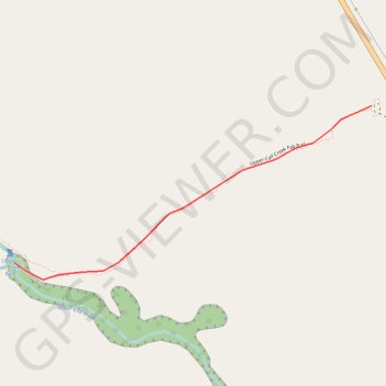
Upper Calf Creek Fall
Hike to Upper Calf Creek Fall via Upper Calf Creek Fall Trail in the Grand Staircase-Escalante National Monument. #Hiking #Fall #River #Nature #Forest
- Distance: 0.9 mi
- Elevation gain: 2 m
- Maximum elevation: 1,988 m
- Elevation loss: 183 m
- Minimum elevation: 1,805 m
- Moving time: 39 m 7 s
- Moving speed: 1.4 mph
- Maximum speed: 2.3 mph
- Total time: 47 m 20 s
- Global speed: 1.1 mph
Interactive trail map
Trail profile
- Distance: 0.9 mi
- Elevation gain: 2 m
- Maximum elevation: 1,988 m
- Elevation loss: 183 m
- Minimum elevation: 1,805 m
- Moving time: 39 m 7 s
- Moving speed: 1.4 mph
- Maximum speed: 2.3 mph
- Total time: 47 m 20 s
- Global speed: 1.1 mph
About this trail
Name: Upper Calf Creek Fall trail, distance, elevation, map, profile, GPS track
End: Upper Calf Creek Fall Trail, Garfield County, Utah, United States (37.85475 -111.45175)
Coordinates: 37.85423 -111.45175 37.85957 -111.43788