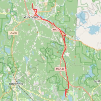
Rail trails and other trails Winchendon/Gardner
- Distance: 19.1 mi
- Elevation gain: 298 m
- Maximum elevation: 344 m
- Elevation loss: 299 m
- Minimum elevation: 291 m
- Moving time: 1 h 45 m
- Moving speed: 10.9 mph
- Maximum speed: 19.7 mph
- Total time: 1 h 47 m
- Global speed: 10.7 mph
Interactive trail map
Trail profile
- Distance: 19.1 mi
- Elevation gain: 298 m
- Maximum elevation: 344 m
- Elevation loss: 299 m
- Minimum elevation: 291 m
- Moving time: 1 h 45 m
- Moving speed: 10.9 mph
- Maximum speed: 19.7 mph
- Total time: 1 h 47 m
- Global speed: 10.7 mph
About this trail
Name: Rail trails and other trails Winchendon/Gardner trail, distance, elevation, map, profile, GPS track
Start: Park Street, Gardner, Worcester County, Massachusetts, 01440, United States (42.59267 -71.99879)
End: Park Street, Gardner, Worcester County, Massachusetts, 01440, United States (42.59245 -71.99883)
Coordinates: 42.59219 -72.05040 42.69612 -71.99525