Histoire de Monein
- Distance: 2.0 mi
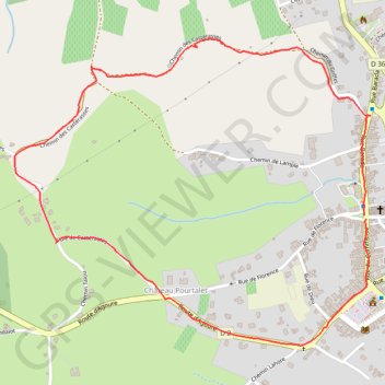
- Elevation gain: 98 m
- Maximum elevation: 246 m
- Elevation loss: 98 m
- Minimum elevation: 148 m
Interactive trail map
Trail profile
- Distance: 2.0 mi
- Elevation gain: 98 m
- Maximum elevation: 246 m
- Elevation loss: 98 m
- Minimum elevation: 148 m
About this trail
Name: Histoire de Monein trail, distance, elevation, map, profile, GPS track
Coordinates: 43.31896 -0.59204 43.32671 -0.57970
Other hiking, mountain biking, running and outdoor activity trails
Click on a trail to view its statistics, map and profile.
GR 10 - Traversée des Pyrénées
France > Occitania > Pyrénées-Orientales > Banyuls-sur-Mer
Distance: 543.6 mi • Elevation gain: 57,000 m • Maximum elevation: 2,599 m
1 LUCENA - MONTPELLIER
Distance: 1,842.0 mi • Elevation gain: 29,500 m • Maximum elevation: 1,048 m
Southern section — European Divide Trail
France > Auvergne-Rhône-Alpes > Drôme > Valence
Distance: 1,506.1 mi • Elevation gain: 42,375 m • Maximum elevation: 2,005 m
Chemin de Saint-Jacques-de-Compostelle
Switzerland > Geneva > Geneva
Distance: 694.6 mi • Elevation gain: 25,262 m • Maximum elevation: 1,430 m