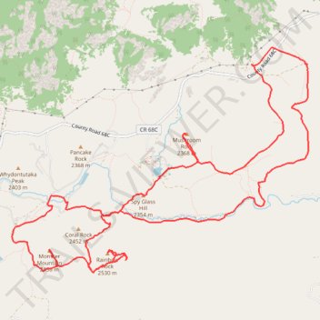
Monster Mountain, Rainbow Rock, Mushroom Rock, Shotgun Lake and Spy Glass Hill loop
- Distance: 11.3 mi
- Elevation gain: 683 m
- Maximum elevation: 2,506 m
- Elevation loss: 684 m
- Minimum elevation: 2,232 m
- Moving time: 4 h 43 m
- Moving speed: 2.4 mph
- Maximum speed: 3.7 mph
- Total time: 5 h 42 m
- Global speed: 2.0 mph
Interactive trail map
Trail profile
- Distance: 11.3 mi
- Elevation gain: 683 m
- Maximum elevation: 2,506 m
- Elevation loss: 684 m
- Minimum elevation: 2,232 m
- Moving time: 4 h 43 m
- Moving speed: 2.4 mph
- Maximum speed: 3.7 mph
- Total time: 5 h 42 m
- Global speed: 2.0 mph
About this trail
Name: Monster Mountain, Rainbow Rock, Mushroom Rock, Shotgun Lake and Spy Glass Hill loop trail, distance, elevation, map, profile, GPS track
Start: Corral Rock Trail, Larimer County, Colorado, United States (40.73709 -105.51681)
End: Corral Rock Trail, Larimer County, Colorado, United States (40.73708 -105.51680)
Coordinates: 40.72795 -105.52332 40.75471 -105.47693