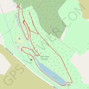
Parc Cwm Darran
Cwm Darran trails
- Distance: 2.5 mi
- Elevation gain: 100 m
- Maximum elevation: 322 m
- Elevation loss: 97 m
- Minimum elevation: 272 m
- Moving time: 57 m 16 s
- Moving speed: 2.6 mph
- Maximum speed: 5.3 mph
- Total time: 59 m 9 s
- Global speed: 2.6 mph
Interactive trail map
Trail profile
- Distance: 2.5 mi
- Elevation gain: 100 m
- Maximum elevation: 322 m
- Elevation loss: 97 m
- Minimum elevation: 272 m
- Moving time: 57 m 16 s
- Moving speed: 2.6 mph
- Maximum speed: 5.3 mph
- Total time: 59 m 9 s
- Global speed: 2.6 mph
About this trail
Name: Parc Cwm Darran trail, distance, elevation, map, profile, GPS track
Coordinates: 51.71919 -3.28509 51.72743 -3.27618
Topography: Caerphilly County Borough topographic map, elevation, terrain
Other hiking, mountain biking, running and outdoor activity trails
Click on a trail to view its statistics, map and profile.
The Headstock 500
United Kingdom > Wales > Newport > Newport
Distance: 300.4 mi • Elevation gain: 9,616 m • Maximum elevation: 691 m
Treorchy, Cearphilly, Pen y Fan
United Kingdom > Wales > Caerphilly County Borough > Tredegar
Distance: 79.1 mi • Elevation gain: 1,934 m • Maximum elevation: 501 m
Parc Cwm Darran Loop
United Kingdom > Wales > Caerphilly County Borough > Tir-Phil
Distance: 5.7 mi • Elevation gain: 214 m • Maximum elevation: 399 m
Cwm Darren
United Kingdom > Wales > Caerphilly County Borough > Deri
Distance: 5.0 mi • Elevation gain: 100 m • Maximum elevation: 296 m