Thank you for supporting this site ❤️
Make a donation
Make a donation
Gear up for your next adventure:
As an Amazon Associate, this site earns from qualifying purchases at no extra cost to you.
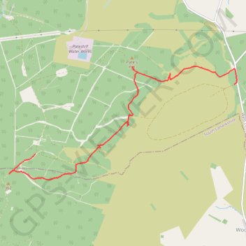
Pates Hill and neighbouring wind farm
- Distance: 3.4 mi
- Elevation gain: 56 m
- Maximum elevation: 361 m
- Elevation loss: 116 m
- Minimum elevation: 260 m
- Moving time: 1 h 8 m
- Moving speed: 3.0 mph
- Maximum speed: 4.3 mph
- Total time: 1 h 11 m
- Global speed: 2.9 mph
Interactive trail map
Thank you for supporting this site ❤️
Make a donation
Make a donation
Gear up for your next adventure:
As an Amazon Associate, this site earns from qualifying purchases at no extra cost to you.
Trail profile
- Distance: 3.4 mi
- Elevation gain: 56 m
- Maximum elevation: 361 m
- Elevation loss: 116 m
- Minimum elevation: 260 m
- Moving time: 1 h 8 m
- Moving speed: 3.0 mph
- Maximum speed: 4.3 mph
- Total time: 1 h 11 m
- Global speed: 2.9 mph
Thank you for supporting this site ❤️
Make a donation
Make a donation
Gear up for your next adventure:
As an Amazon Associate, this site earns from qualifying purchases at no extra cost to you.
About this trail
Name: Pates Hill and neighbouring wind farm trail, distance, elevation, map, profile, GPS track
Start: Hendry's Corse, West Lothian, Scotland, EH55 8JW, United Kingdom (55.80543 -3.63358)
End: West Lothian, Scotland, EH55 8LH, United Kingdom (55.81353 -3.59233)
Coordinates: 55.80242 -3.63907 55.81566 -3.59179
Topography: West Lothian topographic map, elevation, terrain
Thank you for supporting this site ❤️
Make a donation
Make a donation
Gear up for your next adventure:
As an Amazon Associate, this site earns from qualifying purchases at no extra cost to you.