Thank you for supporting this site ❤️
Make a donation
Make a donation
Gear up for your next adventure:
As an Amazon Associate, this site earns from qualifying purchases at no extra cost to you.
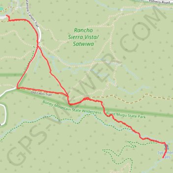
Sycamore Falls
- Distance: 3.7 mi
- Elevation gain: 209 m
- Maximum elevation: 350 m
- Elevation loss: 209 m
- Minimum elevation: 244 m
- Moving time: 1 h 35 m
- Moving speed: 2.3 mph
- Maximum speed: 3.6 mph
- Total time: 2 h 14 m
- Global speed: 1.6 mph
Interactive trail map
Thank you for supporting this site ❤️
Make a donation
Make a donation
Gear up for your next adventure:
As an Amazon Associate, this site earns from qualifying purchases at no extra cost to you.
Trail profile
- Distance: 3.7 mi
- Elevation gain: 209 m
- Maximum elevation: 350 m
- Elevation loss: 209 m
- Minimum elevation: 244 m
- Moving time: 1 h 35 m
- Moving speed: 2.3 mph
- Maximum speed: 3.6 mph
- Total time: 2 h 14 m
- Global speed: 1.6 mph
Thank you for supporting this site ❤️
Make a donation
Make a donation
Gear up for your next adventure:
As an Amazon Associate, this site earns from qualifying purchases at no extra cost to you.
About this trail
Name: Sycamore Falls trail, distance, elevation, map, profile, GPS track
Coordinates: 34.13975 -118.96545 34.15305 -118.94738
Thank you for supporting this site ❤️
Make a donation
Make a donation
Gear up for your next adventure:
As an Amazon Associate, this site earns from qualifying purchases at no extra cost to you.