Make a donation
Gear up for your next adventure:
As an Amazon Associate, this site earns from qualifying purchases at no extra cost to you.
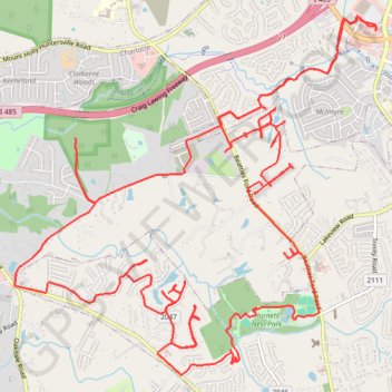
Exploring Long Creek and McIntyre Creek
New Greenway and shoulder lanes
- Distance: 17.4 mi
- Elevation gain: 234 m
- Maximum elevation: 248 m
- Elevation loss: 234 m
- Minimum elevation: 205 m
- Moving time: 1 h 33 m
- Moving speed: 11.2 mph
- Maximum speed: 29.2 mph
- Total time: 1 h 36 m
- Global speed: 10.8 mph
Interactive trail map
Make a donation
Gear up for your next adventure:
As an Amazon Associate, this site earns from qualifying purchases at no extra cost to you.
Trail profile
- Distance: 17.4 mi
- Elevation gain: 234 m
- Maximum elevation: 248 m
- Elevation loss: 234 m
- Minimum elevation: 205 m
- Moving time: 1 h 33 m
- Moving speed: 11.2 mph
- Maximum speed: 29.2 mph
- Total time: 1 h 36 m
- Global speed: 10.8 mph
Make a donation
Gear up for your next adventure:
As an Amazon Associate, this site earns from qualifying purchases at no extra cost to you.
About this trail
Name: Exploring Long Creek and McIntyre Creek trail, distance, elevation, map, profile, GPS track
Coordinates: 35.31390 -80.90193 35.34929 -80.85821
Make a donation
Gear up for your next adventure:
As an Amazon Associate, this site earns from qualifying purchases at no extra cost to you.
Other hiking, mountain biking, running and outdoor activity trails
Click on a trail to view its statistics, map and profile.
North Charlotte
United States > North Carolina > Mecklenburg County > Charlotte
Mapping this city for bikes is a never-ending task
Distance: 20.5 mi • Elevation gain: 308 m • Maximum elevation: 262 m