Goldfields Track - Castlemaine circuit
#MTB #Loop #Goldfields #Castlemaine
- Distance: 10.5 mi
- Elevation gain: 178 m
- Maximum elevation: 382 m
- Elevation loss: 178 m
- Minimum elevation: 272 m
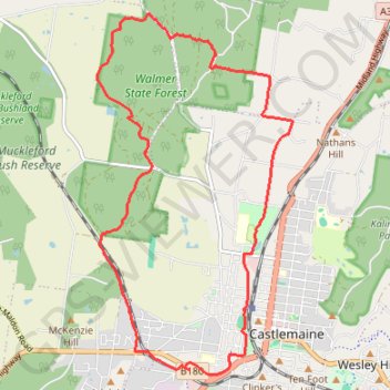
Interactive trail map
Trail profile
- Distance: 10.5 mi
- Elevation gain: 178 m
- Maximum elevation: 382 m
- Elevation loss: 178 m
- Minimum elevation: 272 m
About this trail
Name: Goldfields Track - Castlemaine circuit trail, distance, elevation, map, profile, GPS track
Coordinates: -37.07216 144.18751 -37.02265 144.22111
Other hiking, mountain biking, running and outdoor activity trails
Click on a trail to view its statistics, map and profile.
Maldon- Castlemaine Rail Trail
Distance: 10.5 mi • Elevation gain: 139 m • Maximum elevation: 360 m
Specimen Gully, Pineys, Golden Point Res, Garfield Water Wheel, Chewton, Castlemaine, Botanic gardens walk
Distance: 11.4 mi • Elevation gain: 269 m • Maximum elevation: 468 m