Import a GPX file

Charlie Moreland - Summer Falls - Mount Allan

Conondale National Park. #MTB #Loop #Summer #Allan #Conondale

  • Distance: 20.1 mi
  • Elevation gain: 1,072 m
  • Maximum elevation: 570 m
  • Elevation loss: 1,072 m
  • Minimum elevation: 104 m

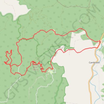
Interactive trail map

Trail profile

  • Distance: 20.1 mi
  • Elevation gain: 1,072 m
  • Maximum elevation: 570 m
  • Elevation loss: 1,072 m
  • Minimum elevation: 104 m

About this trail

Other hiking, mountain biking, running and outdoor activity trails

Click on a trail to view its statistics, map and profile.

Obi Lookout - Cambroon

Australia > Queensland > Sunshine Coast Regional

#MTB #Loop

Distance: 39.6 mi • Elevation gain: 1,648 m • Maximum elevation: 520 m

Imbil Jimna Kenilworth loop

Australia > Queensland > Tewantin

Distance: 134.2 mi • Elevation gain: 3,884 m • Maximum elevation: 822 m

Gear up for your next adventure:

Insulated Travel Mugs - Keep drinks hot while surveying the landscape from a summit
📕Outdoor Navigation Books - Learn traditional and modern navigation techniques
📢Survival Whistles - Essential safety gear for signaling for help in mountain fog
🛰️Outdoor GPS Navigation - Navigation devices for remote and off-grid areas
🥤Collapsible Water Bottles - Save space in your rucksack as you consume your water

As an Amazon Associate, this site earns from qualifying purchases at no extra cost to you.