Thank you for supporting this site ❤️
Make a donation
Make a donation
Gear up for your next adventure:
As an Amazon Associate, this site earns from qualifying purchases at no extra cost to you.
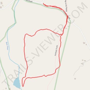
Edge Hill loop walk
- Distance: 1.6 mi
- Elevation gain: 98 m
- Maximum elevation: 397 m
- Elevation loss: 98 m
- Minimum elevation: 312 m
- Moving time: 41 m 34 s
- Moving speed: 2.4 mph
- Maximum speed: 3.9 mph
- Total time: 41 m 34 s
- Global speed: 2.4 mph
Interactive trail map
Thank you for supporting this site ❤️
Make a donation
Make a donation
Gear up for your next adventure:
As an Amazon Associate, this site earns from qualifying purchases at no extra cost to you.
Trail profile
- Distance: 1.6 mi
- Elevation gain: 98 m
- Maximum elevation: 397 m
- Elevation loss: 98 m
- Minimum elevation: 312 m
- Moving time: 41 m 34 s
- Moving speed: 2.4 mph
- Maximum speed: 3.9 mph
- Total time: 41 m 34 s
- Global speed: 2.4 mph
Thank you for supporting this site ❤️
Make a donation
Make a donation
Gear up for your next adventure:
As an Amazon Associate, this site earns from qualifying purchases at no extra cost to you.
About this trail
Name: Edge Hill loop walk trail, distance, elevation, map, profile, GPS track
Coordinates: 42.55169 -72.78020 42.55879 -72.77490
Thank you for supporting this site ❤️
Make a donation
Make a donation
Gear up for your next adventure:
As an Amazon Associate, this site earns from qualifying purchases at no extra cost to you.