Munro, Hillwalk, Skye, Bla, Bheinn, Blaven
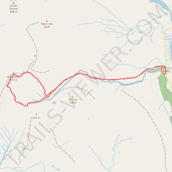
- Distance: 5.8 mi
- Elevation gain: 943 m
- Maximum elevation: 921 m
- Elevation loss: 943 m
- Minimum elevation: 7 m
- Moving time: 3 h 47 m
- Moving speed: 1.5 mph
- Maximum speed: 3.4 mph
- Total time: 5 h 19 m
- Global speed: 1.1 mph
Interactive trail map
Trail profile
- Distance: 5.8 mi
- Elevation gain: 943 m
- Maximum elevation: 921 m
- Elevation loss: 943 m
- Minimum elevation: 7 m
- Moving time: 3 h 47 m
- Moving speed: 1.5 mph
- Maximum speed: 3.4 mph
- Total time: 5 h 19 m
- Global speed: 1.1 mph
About this trail
Name: Munro, Hillwalk, Skye, Bla, Bheinn, Blaven trail, distance, elevation, map, profile, GPS track
Start: Blà Bheinn Car Park, B8083, Highland, Scotland, IV49 9AU, United Kingdom (57.21988 -6.04293)
End: Blà Bheinn Car Park, B8083, Highland, Scotland, IV49 9AU, United Kingdom (57.21985 -6.04282)
Coordinates: 57.21362 -6.09552 57.22105 -6.04140
Topography: Highland topographic map, elevation, terrain