Ibis Lake circuit
- Distance: 7.2 mi
- Elevation gain: 36 m
- Maximum elevation: 315 m
- Elevation loss: 21 m
- Minimum elevation: 293 m
- Moving time: 2 h 10 m
- Moving speed: 3.3 mph
- Maximum speed: 21.6 mph
- Total time: 3 h 6 m
- Global speed: 2.3 mph
Interactive trail map
Trail profile
- Distance: 7.2 mi
- Elevation gain: 36 m
- Maximum elevation: 315 m
- Elevation loss: 21 m
- Minimum elevation: 293 m
- Moving time: 2 h 10 m
- Moving speed: 3.3 mph
- Maximum speed: 21.6 mph
- Total time: 3 h 6 m
- Global speed: 2.3 mph
About this trail
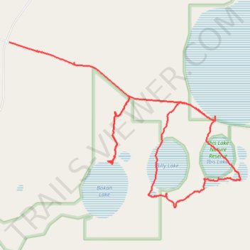
Name: Ibis Lake circuit trail, distance, elevation, map, profile, GPS track
Start: Lakes Road, Nomans Lake, Shire Of Narrogin, Western Australia, Australia (-32.98314 117.54292)
End: Lakes Road, Nomans Lake, Shire Of Narrogin, Western Australia, Australia (-32.97296 117.51081)
Coordinates: -32.99458 117.51081 -32.97296 117.54686