Partridge Hills
- Distance: 6.0 mi
- Elevation gain: 269 m
- Maximum elevation: 285 m
- Elevation loss: 269 m
- Minimum elevation: 122 m
- Moving time: 2 h 48 m
- Moving speed: 2.1 mph
- Maximum speed: 10.3 mph
- Total time: 3 h 41 m
- Global speed: 1.6 mph
Interactive trail map
Trail profile
- Distance: 6.0 mi
- Elevation gain: 269 m
- Maximum elevation: 285 m
- Elevation loss: 269 m
- Minimum elevation: 122 m
- Moving time: 2 h 48 m
- Moving speed: 2.1 mph
- Maximum speed: 10.3 mph
- Total time: 3 h 41 m
- Global speed: 1.6 mph
About this trail
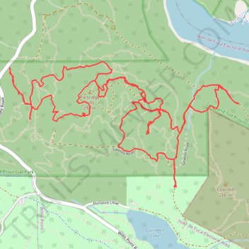
Name: Partridge Hills trail, distance, elevation, map, profile, GPS track
Coordinates: 48.55064 -123.49146 48.55854 -123.46964
Other hiking, mountain biking, running and outdoor activity trails
Click on a trail to view its statistics, map and profile.
Durrance Lake - Tod creek and inlet
Canada > British Columbia > Capital Regional District > Juan de Fuca Electoral Area
Gowlland Tod Provincial Park. #Hiking #Loop #GowllandTod
Distance: 7.2 mi • Elevation gain: 452 m • Maximum elevation: 265 m
Mount Work - Mount Stewart - Thetis Lake
Canada > British Columbia > Capital Regional District > Highlands
Distance: 12.6 mi • Elevation gain: 697 m • Maximum elevation: 436 m
BBF loop to the Skydeck in Nanaimo
Canada > British Columbia > Cowichan Valley Regional District > Area A (Mill Bay / Malahat) > Mill Bay
BBF loop to the Skydeck
Distance: 201.0 mi • Elevation gain: 6,222 m • Maximum elevation: 706 m