Thank you for supporting this site ❤️
Make a donation
Make a donation
Gear up for your next adventure:
As an Amazon Associate, this site earns from qualifying purchases at no extra cost to you.
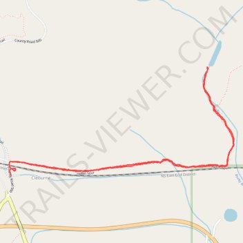
Heflin Spur to old Alabama Power dam
- Distance: 2.4 mi
- Elevation gain: 78 m
- Maximum elevation: 306 m
- Elevation loss: 77 m
- Minimum elevation: 280 m
- Moving time: 57 m 40 s
- Moving speed: 2.5 mph
- Maximum speed: 5.0 mph
- Total time: 1 h 15 m
- Global speed: 1.9 mph
Interactive trail map
Thank you for supporting this site ❤️
Make a donation
Make a donation
Gear up for your next adventure:
As an Amazon Associate, this site earns from qualifying purchases at no extra cost to you.
Trail profile
- Distance: 2.4 mi
- Elevation gain: 78 m
- Maximum elevation: 306 m
- Elevation loss: 77 m
- Minimum elevation: 280 m
- Moving time: 57 m 40 s
- Moving speed: 2.5 mph
- Maximum speed: 5.0 mph
- Total time: 1 h 15 m
- Global speed: 1.9 mph
Thank you for supporting this site ❤️
Make a donation
Make a donation
Gear up for your next adventure:
As an Amazon Associate, this site earns from qualifying purchases at no extra cost to you.
About this trail
Name: Heflin Spur to old Alabama Power dam trail, distance, elevation, map, profile, GPS track
Start: County Road 500, Cleburne, Cleburne County, Alabama, United States (33.64867 -85.63145)
End: County Road 500, Cleburne, Cleburne County, Alabama, United States (33.64821 -85.63138)
Coordinates: 33.64821 -85.63149 33.65341 -85.61868
Thank you for supporting this site ❤️
Make a donation
Make a donation
Gear up for your next adventure:
As an Amazon Associate, this site earns from qualifying purchases at no extra cost to you.