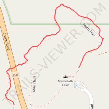
Marri Trail
- Distance: 0.5 mi
- Elevation gain: 11 m
- Maximum elevation: 84 m
- Elevation loss: 22 m
- Minimum elevation: 61 m
- Moving time: 14 m 14 s
- Moving speed: 2.1 mph
- Maximum speed: 3.8 mph
- Total time: 14 m 14 s
- Global speed: 2.1 mph
Interactive trail map
Trail profile
- Distance: 0.5 mi
- Elevation gain: 11 m
- Maximum elevation: 84 m
- Elevation loss: 22 m
- Minimum elevation: 61 m
- Moving time: 14 m 14 s
- Moving speed: 2.1 mph
- Maximum speed: 3.8 mph
- Total time: 14 m 14 s
- Global speed: 2.1 mph
About this trail
Name: Marri Trail trail, distance, elevation, map, profile, GPS track
Coordinates: -34.05954 115.02763 -34.05662 115.03105
Other hiking, mountain biking, running and outdoor activity trails
Click on a trail to view its statistics, map and profile.
Part 2 38.9m
Distance: 38.9 mi • Elevation gain: 1,036 m • Maximum elevation: 187 m