Simpson Woods Preserve Blue Trail
- Distance: 1.6 mi
- Elevation gain: 25 m
- Maximum elevation: 68 m
- Elevation loss: 25 m
- Minimum elevation: 45 m
- Moving time: 46 m 59 s
- Moving speed: 2.1 mph
- Maximum speed: 3.6 mph
- Total time: 46 m 59 s
- Global speed: 2.1 mph
Interactive trail map
Trail profile
- Distance: 1.6 mi
- Elevation gain: 25 m
- Maximum elevation: 68 m
- Elevation loss: 25 m
- Minimum elevation: 45 m
- Moving time: 46 m 59 s
- Moving speed: 2.1 mph
- Maximum speed: 3.6 mph
- Total time: 46 m 59 s
- Global speed: 2.1 mph
About this trail
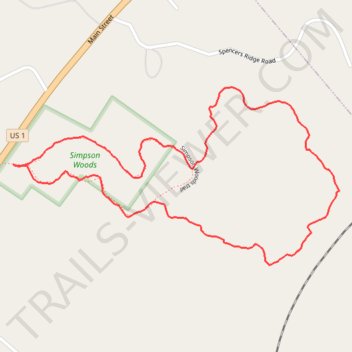
Name: Simpson Woods Preserve Blue Trail trail, distance, elevation, map, profile, GPS track
Start: Simpson Woods trail, Freeport, Cumberland County, Maine, 04032, United States (43.89375 -70.07067)
End: Simpson Woods trail, Freeport, Cumberland County, Maine, 04032, United States (43.89374 -70.07070)
Coordinates: 43.89141 -70.07070 43.89554 -70.06021