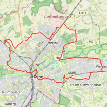
Hoeveler Strasse, Hamm - Mansfelder Strasse 64, Hamm
Loop from Hamm.
- Distance: 20.2 mi
- Elevation gain: 147 m
- Maximum elevation: 97 m
- Elevation loss: 149 m
- Minimum elevation: 56 m
- Moving time: 2 h 10 m
- Moving speed: 9.3 mph
- Maximum speed: 13.0 mph
- Total time: 2 h 10 m
- Global speed: 9.3 mph
Interactive trail map
Trail profile
- Distance: 20.2 mi
- Elevation gain: 147 m
- Maximum elevation: 97 m
- Elevation loss: 149 m
- Minimum elevation: 56 m
- Moving time: 2 h 10 m
- Moving speed: 9.3 mph
- Maximum speed: 13.0 mph
- Total time: 2 h 10 m
- Global speed: 9.3 mph
About this trail
Name: Hoeveler Strasse, Hamm - Mansfelder Strasse 64, Hamm trail, distance, elevation, map, profile, GPS track
Coordinates: 51.67541 7.77400 51.72016 7.89309
Other hiking, mountain biking, running and outdoor activity trails
Click on a trail to view its statistics, map and profile.
Görlitz - Alpen
Germany > Saxony > Görlitz > Görlitz
Distance: 465.7 mi • Elevation gain: 5,160 m • Maximum elevation: 446 m
Görlitz - Alpen
Germany > Saxony > Görlitz > Görlitz
Distance: 465.7 mi • Elevation gain: 5,160 m • Maximum elevation: 446 m
Track vom: 2020-06-13 07:00
Germany > North Rhine-Westphalia > Kreis Wesel > Schermbeck
Distance: 422.5 mi • Elevation gain: 5,301 m • Maximum elevation: 921 m
Track vom: 2020-06-27 07:26
Germany > Bavaria > Landkreis Ostallgäu > Halblech
Distance: 427.6 mi • Elevation gain: 4,307 m • Maximum elevation: 911 m
Eurovelo 15 - Strasbourg Rotterdam
France > Grand Est > Bas-Rhin > Strasbourg
Distance: 554.1 mi • Elevation gain: 2,104 m • Maximum elevation: 146 m
PT23BS1 Kiel → Lörrach
Germany > Schleswig-Holstein > Kiel
Distance: 650.4 mi • Elevation gain: 9,265 m • Maximum elevation: 757 m