Thank you for supporting this site ❤️
Make a donation
Make a donation
Gear up for your next adventure:
As an Amazon Associate, this site earns from qualifying purchases at no extra cost to you.
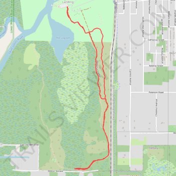
Pine Island Trail at Blue Springs State Park, Orange City, FL
- Distance: 4.2 mi
- Elevation gain: 36 m
- Maximum elevation: 16 m
- Elevation loss: 36 m
- Minimum elevation: 5 m
- Moving time: 1 h 40 m
- Moving speed: 2.5 mph
- Maximum speed: 3.2 mph
- Total time: 1 h 49 m
- Global speed: 2.3 mph
Interactive trail map
Thank you for supporting this site ❤️
Make a donation
Make a donation
Gear up for your next adventure:
As an Amazon Associate, this site earns from qualifying purchases at no extra cost to you.
Trail profile
- Distance: 4.2 mi
- Elevation gain: 36 m
- Maximum elevation: 16 m
- Elevation loss: 36 m
- Minimum elevation: 5 m
- Moving time: 1 h 40 m
- Moving speed: 2.5 mph
- Maximum speed: 3.2 mph
- Total time: 1 h 49 m
- Global speed: 2.3 mph
Thank you for supporting this site ❤️
Make a donation
Make a donation
Gear up for your next adventure:
As an Amazon Associate, this site earns from qualifying purchases at no extra cost to you.
About this trail
Name: Pine Island Trail at Blue Springs State Park, Orange City, FL trail, distance, elevation, map, profile, GPS track
Coordinates: 28.91967 -81.33989 28.94237 -81.33322
Thank you for supporting this site ❤️
Make a donation
Make a donation
Gear up for your next adventure:
As an Amazon Associate, this site earns from qualifying purchases at no extra cost to you.