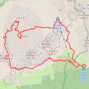
Виаферата Доломити
- Distance: 6.9 mi
- Elevation gain: 1,945 m
- Maximum elevation: 3,010 m
- Elevation loss: 1,945 m
- Minimum elevation: 2,035 m
- Moving time: 4 h 17 m
- Moving speed: 1.6 mph
- Maximum speed: 5.1 mph
- Total time: 9 h 4 m
- Global speed: 0.8 mph
Interactive trail map
Trail profile
- Distance: 6.9 mi
- Elevation gain: 1,945 m
- Maximum elevation: 3,010 m
- Elevation loss: 1,945 m
- Minimum elevation: 2,035 m
- Moving time: 4 h 17 m
- Moving speed: 1.6 mph
- Maximum speed: 5.1 mph
- Total time: 9 h 4 m
- Global speed: 0.8 mph
About this trail
Name: Виаферата Доломити trail, distance, elevation, map, profile, GPS track
Start: SR48, Cortina d'Ampezzo, Belluno, Veneto, 32043, Italy (46.53270 12.07038)
End: SR48, Cortina d'Ampezzo, Belluno, Veneto, 32043, Italy (46.53269 12.07039)
Coordinates: 46.53214 12.04161 46.54455 12.07072