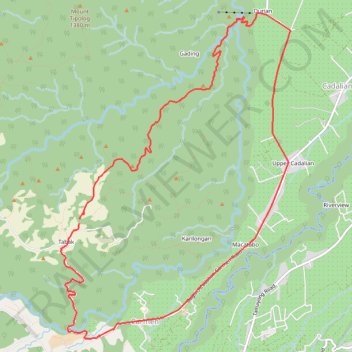
Tabak Durian Loop
- Distance: 11.2 mi
- Elevation gain: 818 m
- Maximum elevation: 1,247 m
- Elevation loss: 814 m
- Minimum elevation: 537 m
- Moving time: 3 h 12 m
- Moving speed: 3.5 mph
- Maximum speed: 15.5 mph
- Total time: 6 h 15 m
- Global speed: 1.8 mph
Interactive trail map
Trail profile
- Distance: 11.2 mi
- Elevation gain: 818 m
- Maximum elevation: 1,247 m
- Elevation loss: 814 m
- Minimum elevation: 537 m
- Moving time: 3 h 12 m
- Moving speed: 3.5 mph
- Maximum speed: 15.5 mph
- Total time: 6 h 15 m
- Global speed: 1.8 mph
About this trail
Name: Tabak Durian Loop trail, distance, elevation, map, profile, GPS track
Start: Tabak, Baguio District, Davao City, Davao Region, 8000, Philippines (7.12877 125.33579)
End: Tabak, Baguio District, Davao City, Davao Region, 8000, Philippines (7.12807 125.33567)
Coordinates: 7.11103 125.33298 7.15925 125.36727