La forêt du Mont-Dieu
- Distance: 12.8 mi
- Elevation gain: 331 m
- Maximum elevation: 272 m
- Elevation loss: 328 m
- Minimum elevation: 159 m
- Moving time: 4 h 39 m
- Moving speed: 2.8 mph
- Maximum speed: 7.1 mph
- Total time: 4 h 50 m
- Global speed: 2.7 mph
Interactive trail map
Trail profile
- Distance: 12.8 mi
- Elevation gain: 331 m
- Maximum elevation: 272 m
- Elevation loss: 328 m
- Minimum elevation: 159 m
- Moving time: 4 h 39 m
- Moving speed: 2.8 mph
- Maximum speed: 7.1 mph
- Total time: 4 h 50 m
- Global speed: 2.7 mph
About this trail
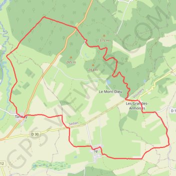
Name: La forêt du Mont-Dieu trail, distance, elevation, map, profile, GPS track
Coordinates: 49.51231 4.82490 49.55964 4.90835
Other hiking, mountain biking, running and outdoor activity trails
Click on a trail to view its statistics, map and profile.
Eurovelo 15 - Strasbourg Rotterdam
France > Grand Est > Bas-Rhin > Strasbourg
Distance: 554.1 mi • Elevation gain: 2,104 m • Maximum elevation: 146 m