Import a GPX file

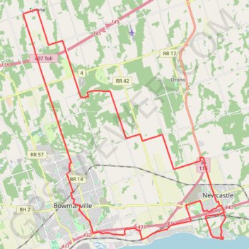
Newcastle - Tyrone Loop

#Bike #Loop #Newcastle #Tyrone

  • Distance: 31.1 mi
  • Elevation gain: 323 m
  • Maximum elevation: 223 m
  • Elevation loss: 325 m
  • Minimum elevation: 78 m

Interactive trail map

Trail profile

  • Distance: 31.1 mi
  • Elevation gain: 323 m
  • Maximum elevation: 223 m
  • Elevation loss: 325 m
  • Minimum elevation: 78 m

About this trail

Other hiking, mountain biking, running and outdoor activity trails

Click on a trail to view its statistics, map and profile.

Québec - Montréal - Saint-Laurent River - Lake Ontario - Niagara Falls

Canada > Quebec > Urban agglomeration of Québec > Quebec

#Bike #Ontario

Distance: 670.1 mi • Elevation gain: 4,804 m • Maximum elevation: 209 m

Scarborough - Cobourg

Canada > Ontario > Toronto

Lake Ontario. #Bike #Scarborough #Cobourg #Toronto #Ontario

Distance: 66.7 mi • Elevation gain: 717 m • Maximum elevation: 130 m

Lake Ontario Waterfront Trail

Canada > Ontario > Durham Region > Pickering

#Hiking #Bike #Ontario

Distance: 50.1 mi • Elevation gain: 598 m • Maximum elevation: 129 m

Oshawa - Cobourg

Canada > Ontario > Durham Region > Oshawa

#Bike

Distance: 41.4 mi • Elevation gain: 453 m • Maximum elevation: 130 m

Gear up for your next adventure:

👟Heavy Duty Boot Laces - Always carry a spare for your hiking footwear
Insulated Travel Mugs - Keep drinks hot while surveying the landscape from a summit
🌦️Portable Weather Meters - Handheld tools for monitoring weather conditions
👟Waterproof Leg Gaiters - Keep mud and water out of your boots in boggy terrain
📱Phone Mounts for Hiking - Secure mounts to carry your phone on trails

As an Amazon Associate, this site earns from qualifying purchases at no extra cost to you.