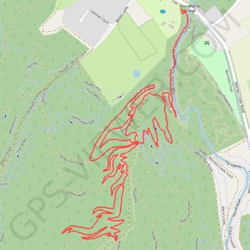
Mountain Bike Ride in Porepunkah Plantation
Interactive trail map
Trail profile
- Distance: 4.5 mi
- Elevation gain: 327 m
- Maximum elevation: 550 m
- Elevation loss: 308 m
- Minimum elevation: 324 m
- Moving time: 45 m 2 s
- Moving speed: 6.0 mph
- Maximum speed: 7.4 mph
- Total time: 45 m 2 s
- Global speed: 6.0 mph
About this trail
Name: Mountain Bike Ride in Porepunkah Plantation trail, distance, elevation, map, profile, GPS track
Start: Short And Sweet, Bright, Alpine Shire, Victoria, 3741, Australia (-36.74270 146.97664)
Coordinates: -36.75288 146.96975 -36.74263 146.97670
Other hiking, mountain biking, running and outdoor activity trails
Click on a trail to view its statistics, map and profile.
Mount Beauty - Pyramid Hill - Bright
Australia > Victoria > Mount Beauty
#MTB
Distance: 29.7 mi • Elevation gain: 1,714 m • Maximum elevation: 1,373 m
Bright Moutain Bike Park
Porepunkah Plantation. #MTB #Loop #Porepunkah
Distance: 13.3 mi • Elevation gain: 452 m • Maximum elevation: 517 m