Hammond Pond Reservation loop
- Distance: 1.9 mi
- Elevation gain: 19 m
- Maximum elevation: 71 m
- Elevation loss: 17 m
- Minimum elevation: 56 m
- Moving time: 57 m 8 s
- Moving speed: 2.0 mph
- Maximum speed: 3.7 mph
- Total time: 6 h 4 m
- Global speed: 0.3 mph
Interactive trail map
Trail profile
- Distance: 1.9 mi
- Elevation gain: 19 m
- Maximum elevation: 71 m
- Elevation loss: 17 m
- Minimum elevation: 56 m
- Moving time: 57 m 8 s
- Moving speed: 2.0 mph
- Maximum speed: 3.7 mph
- Total time: 6 h 4 m
- Global speed: 0.3 mph
About this trail
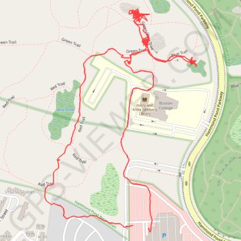
Name: Hammond Pond Reservation loop trail, distance, elevation, map, profile, GPS track
Coordinates: 42.32252 -71.18088 42.32744 -71.17637
Other hiking, mountain biking, running and outdoor activity trails
Click on a trail to view its statistics, map and profile.
2024 Bikes Not Bombs Bike-a-thon (BAT) Agony & Ecstasy
United States > Massachusetts > Suffolk County > Boston
Distance: 106.4 mi • Elevation gain: 1,714 m • Maximum elevation: 183 m
Loop in Eastern Mass involving various rail trails
United States > Massachusetts > Middlesex County > Newton
Distance: 126.6 mi • Elevation gain: 1,940 m • Maximum elevation: 194 m
Cambridge - Providence Express
United States > Massachusetts > Middlesex County > Cambridge
Alewife -> Providence
Distance: 63.2 mi • Elevation gain: 961 m • Maximum elevation: 107 m