Make a donation
Gear up for your next adventure:
As an Amazon Associate, this site earns from qualifying purchases at no extra cost to you.
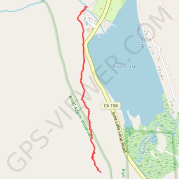
Rush Creek Trail
- Distance: 2.1 mi
- Elevation gain: 202 m
- Maximum elevation: 2,396 m
- Elevation loss: 202 m
- Minimum elevation: 2,211 m
- Moving time: 58 m 16 s
- Moving speed: 2.2 mph
- Maximum speed: 14.0 mph
- Total time: 2 h 10 m
- Global speed: 1.0 mph
Interactive trail map
Make a donation
Gear up for your next adventure:
As an Amazon Associate, this site earns from qualifying purchases at no extra cost to you.
Trail profile
- Distance: 2.1 mi
- Elevation gain: 202 m
- Maximum elevation: 2,396 m
- Elevation loss: 202 m
- Minimum elevation: 2,211 m
- Moving time: 58 m 16 s
- Moving speed: 2.2 mph
- Maximum speed: 14.0 mph
- Total time: 2 h 10 m
- Global speed: 1.0 mph
Make a donation
Gear up for your next adventure:
As an Amazon Associate, this site earns from qualifying purchases at no extra cost to you.
About this trail
Name: Rush Creek Trail trail, distance, elevation, map, profile, GPS track
Start: Rush Creek Trail, Mono County, California, 93529, United States (37.78176 -119.12931)
End: Rush Creek Trail, Mono County, California, 93529, United States (37.78178 -119.12937)
Coordinates: 37.76878 -119.13025 37.78180 -119.12794
Make a donation
Gear up for your next adventure:
As an Amazon Associate, this site earns from qualifying purchases at no extra cost to you.
Other hiking, mountain biking, running and outdoor activity trails
Click on a trail to view its statistics, map and profile.
Mammoth to Bridgeport
United States > California > Mono County > Mammoth Lakes
Northern California Backcountry Discovery Route (CABDR-North)
Distance: 94.8 mi • Elevation gain: 2,191 m • Maximum elevation: 2,822 m