Thank you for supporting this site ❤️
Make a donation
Make a donation
Gear up for your next adventure:
As an Amazon Associate, this site earns from qualifying purchases at no extra cost to you.
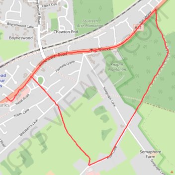
Four Marks Weathermore Lane
- Distance: 2.3 mi
- Elevation gain: 36 m
- Maximum elevation: 215 m
- Elevation loss: 45 m
- Minimum elevation: 193 m
- Moving time: 21 m 16 s
- Moving speed: 6.6 mph
- Maximum speed: 8.0 mph
- Total time: 21 m 16 s
- Global speed: 6.6 mph
Interactive trail map
Thank you for supporting this site ❤️
Make a donation
Make a donation
Gear up for your next adventure:
As an Amazon Associate, this site earns from qualifying purchases at no extra cost to you.
Trail profile
- Distance: 2.3 mi
- Elevation gain: 36 m
- Maximum elevation: 215 m
- Elevation loss: 45 m
- Minimum elevation: 193 m
- Moving time: 21 m 16 s
- Moving speed: 6.6 mph
- Maximum speed: 8.0 mph
- Total time: 21 m 16 s
- Global speed: 6.6 mph
Thank you for supporting this site ❤️
Make a donation
Make a donation
Gear up for your next adventure:
As an Amazon Associate, this site earns from qualifying purchases at no extra cost to you.
About this trail
Name: Four Marks Weathermore Lane trail, distance, elevation, map, profile, GPS track
Coordinates: 51.10683 -1.04456 51.11753 -1.02691
Topography: East Hampshire topographic map, elevation, terrain
Thank you for supporting this site ❤️
Make a donation
Make a donation
Gear up for your next adventure:
As an Amazon Associate, this site earns from qualifying purchases at no extra cost to you.