Thank you for supporting this site ❤️
Make a donation
Make a donation
Gear up for your next adventure:
As an Amazon Associate, this site earns from qualifying purchases at no extra cost to you.
Pennsylvania Mountain Trail
colorado, usa
- Distance: 5.3 mi
- Elevation gain: 473 m
- Maximum elevation: 3,970 m
- Elevation loss: 473 m
- Minimum elevation: 3,554 m
- Moving time: 4 h 16 m
- Moving speed: 1.2 mph
- Maximum speed: 3.1 mph
- Total time: 5 h 54 m
- Global speed: 0.9 mph
Interactive trail map
Thank you for supporting this site ❤️
Make a donation
Make a donation
Gear up for your next adventure:
As an Amazon Associate, this site earns from qualifying purchases at no extra cost to you.
Trail profile
- Distance: 5.3 mi
- Elevation gain: 473 m
- Maximum elevation: 3,970 m
- Elevation loss: 473 m
- Minimum elevation: 3,554 m
- Moving time: 4 h 16 m
- Moving speed: 1.2 mph
- Maximum speed: 3.1 mph
- Total time: 5 h 54 m
- Global speed: 0.9 mph
Thank you for supporting this site ❤️
Make a donation
Make a donation
Gear up for your next adventure:
As an Amazon Associate, this site earns from qualifying purchases at no extra cost to you.
About this trail
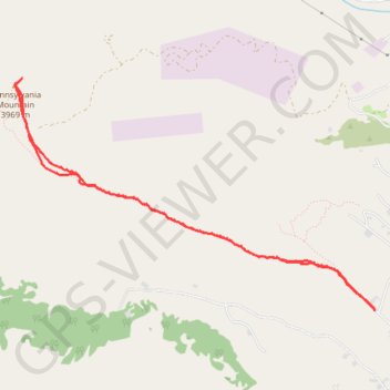
Name: Pennsylvania Mountain Trail trail, distance, elevation, map, profile, GPS track
Start: Mountain View Drive, Park County, Colorado, United States (39.24678 -106.10541)
End: Mountain View Drive, Park County, Colorado, United States (39.24677 -106.10537)
Coordinates: 39.24677 -106.14226 39.26520 -106.10537
Thank you for supporting this site ❤️
Make a donation
Make a donation
Gear up for your next adventure:
As an Amazon Associate, this site earns from qualifying purchases at no extra cost to you.