Thank you for supporting this site ❤️
Make a donation
Make a donation
Gear up for your next adventure:
As an Amazon Associate, this site earns from qualifying purchases at no extra cost to you.
Herman Gulch Lake
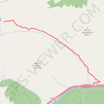
Interactive trail map
Thank you for supporting this site ❤️
Make a donation
Make a donation
Gear up for your next adventure:
As an Amazon Associate, this site earns from qualifying purchases at no extra cost to you.
Trail profile
- Distance: 6.3 mi
- Elevation gain: 521 m
- Maximum elevation: 3,663 m
- Elevation loss: 521 m
- Minimum elevation: 3,142 m
Thank you for supporting this site ❤️
Make a donation
Make a donation
Gear up for your next adventure:
As an Amazon Associate, this site earns from qualifying purchases at no extra cost to you.
About this trail
Name: Herman Gulch Lake trail, distance, elevation, map, profile, GPS track
Start: Watrous Way, Clear Creek County, Colorado, United States (39.70243 -105.85371)
End: Watrous Way, Clear Creek County, Colorado, United States (39.70243 -105.85371)
Coordinates: 39.70241 -105.89331 39.72374 -105.85119
Thank you for supporting this site ❤️
Make a donation
Make a donation
Gear up for your next adventure:
As an Amazon Associate, this site earns from qualifying purchases at no extra cost to you.