Westwoods in Guilford CT
- Distance: 3.4 mi
- Elevation gain: 77 m
- Maximum elevation: 35 m
- Elevation loss: 83 m
- Minimum elevation: 9 m
- Moving time: 1 h 55 m
- Moving speed: 1.8 mph
- Maximum speed: 3.3 mph
- Total time: 2 h 14 m
- Global speed: 1.5 mph
Interactive trail map
Trail profile
- Distance: 3.4 mi
- Elevation gain: 77 m
- Maximum elevation: 35 m
- Elevation loss: 83 m
- Minimum elevation: 9 m
- Moving time: 1 h 55 m
- Moving speed: 1.8 mph
- Maximum speed: 3.3 mph
- Total time: 2 h 14 m
- Global speed: 1.5 mph
About this trail
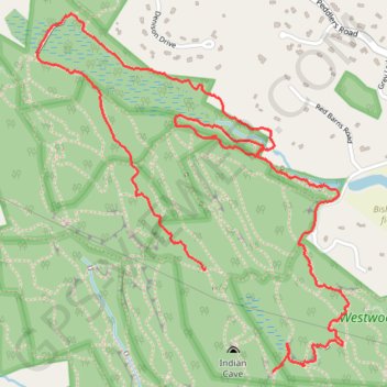
Name: Westwoods in Guilford CT trail, distance, elevation, map, profile, GPS track
Coordinates: 41.28048 -72.71833 41.29323 -72.70354
Other hiking, mountain biking, running and outdoor activity trails
Click on a trail to view its statistics, map and profile.
Westwoods green triangle and square near Dunk Rock Road
United States > Connecticut > South Central Connecticut Planning Region > Guilford
Distance: 2.8 mi • Elevation gain: 68 m • Maximum elevation: 36 m
Revised Red Triangle Trail in Westwoods, Guilford CT
United States > Connecticut > South Central Connecticut Planning Region > Guilford
Distance: 5.8 mi • Elevation gain: 142 m • Maximum elevation: 44 m