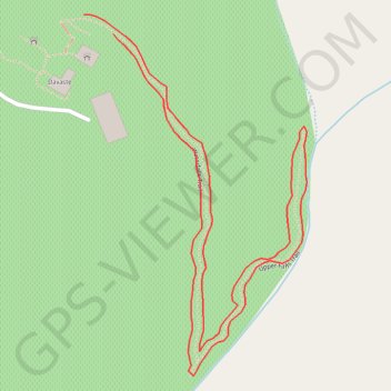
Waterfalls Trail
Iredell County Hike
- Distance: 0.7 mi
- Elevation gain: 15 m
- Maximum elevation: 263 m
- Elevation loss: 15 m
- Minimum elevation: 249 m
- Moving time: 21 m 25 s
- Moving speed: 2.0 mph
- Maximum speed: 4.2 mph
- Total time: 21 m 25 s
- Global speed: 2.0 mph
Interactive trail map
Trail profile
- Distance: 0.7 mi
- Elevation gain: 15 m
- Maximum elevation: 263 m
- Elevation loss: 15 m
- Minimum elevation: 249 m
- Moving time: 21 m 25 s
- Moving speed: 2.0 mph
- Maximum speed: 4.2 mph
- Total time: 21 m 25 s
- Global speed: 2.0 mph
About this trail
Name: Waterfalls Trail trail, distance, elevation, map, profile, GPS track
Start: Waterfalls Trail, Iredell County, North Carolina, 28166, United States (35.69073 -80.90253)
End: Waterfalls Trail, Iredell County, North Carolina, 28166, United States (35.69058 -80.90225)
Coordinates: 35.68797 -80.90253 35.69073 -80.90043