GravelBike_20Miles
Evening Ride
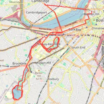
- Distance: 22.0 mi
- Elevation gain: 249 m
- Maximum elevation: 33 m
- Elevation loss: 261 m
- Minimum elevation: 0 m
- Moving time: 1 h 45 m
- Moving speed: 12.5 mph
- Maximum speed: 28.9 mph
- Total time: 1 h 57 m
- Global speed: 11.3 mph
Interactive trail map
Trail profile
- Distance: 22.0 mi
- Elevation gain: 249 m
- Maximum elevation: 33 m
- Elevation loss: 261 m
- Minimum elevation: 0 m
- Moving time: 1 h 45 m
- Moving speed: 12.5 mph
- Maximum speed: 28.9 mph
- Total time: 1 h 57 m
- Global speed: 11.3 mph
About this trail
Name: GravelBike_20Miles trail, distance, elevation, map, profile, GPS track
Coordinates: 42.31378 -71.12390 42.36401 -71.06769
Other hiking, mountain biking, running and outdoor activity trails
Click on a trail to view its statistics, map and profile.
Charles River Trails in Watertown, Newton, Cambridge, Boston
United States > Massachusetts > Middlesex County > Newton
River Ride, both sides
Distance: 16.4 mi • Elevation gain: 166 m • Maximum elevation: 14 m
2024 Bikes Not Bombs Bike-a-thon (BAT) Agony & Ecstasy
United States > Massachusetts > Suffolk County > Boston
Distance: 106.4 mi • Elevation gain: 1,714 m • Maximum elevation: 183 m
Nahant and Northern Strand Trail
United States > Massachusetts > Suffolk County > Boston
Distance: 43.7 mi • Elevation gain: 388 m • Maximum elevation: 23 m