Charon's Garden Trail and Elk Mountain Trail hiking in Wichita Mountains Wildlife Refuge
- Distance: 8.6 mi
- Elevation gain: 352 m
- Maximum elevation: 678 m
- Elevation loss: 352 m
- Minimum elevation: 456 m
- Moving time: 4 h 12 m
- Moving speed: 2.0 mph
- Maximum speed: 3.9 mph
- Total time: 4 h 58 m
- Global speed: 1.7 mph
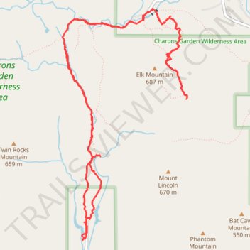
Interactive trail map
Trail profile
- Distance: 8.6 mi
- Elevation gain: 352 m
- Maximum elevation: 678 m
- Elevation loss: 352 m
- Minimum elevation: 456 m
- Moving time: 4 h 12 m
- Moving speed: 2.0 mph
- Maximum speed: 3.9 mph
- Total time: 4 h 58 m
- Global speed: 1.7 mph
About this trail
Name: Charon's Garden Trail and Elk Mountain Trail hiking in Wichita Mountains Wildlife Refuge trail, distance, elevation, map, profile, GPS track
Start: Charon's Garden Trail, Comanche County, Oklahoma, United States (34.70678 -98.73319)
End: Charon's Garden Trail, Comanche County, Oklahoma, United States (34.70661 -98.73333)
Coordinates: 34.70440 -98.73661 34.73177 -98.71853
Other hiking, mountain biking, running and outdoor activity trails
Click on a trail to view its statistics, map and profile.
Elk Mountain Trail in Charons Garden Wilderness Area
United States > Oklahoma > Comanche County
The Elk Mountain Trail offers a rewarding hiking experience with its gradual ascent leading to stunning panoramic views of the Wichita Mountains, Mount Lincoln and surrounding landscapes. Along the route, hikers can encounter unique geological features, including granite slabs and boulder formations, as well…
Distance: 2.3 mi • Elevation gain: 178 m • Maximum elevation: 678 m