Cyfarthfa Park paths
- Distance: 1.5 mi
- Elevation gain: 73 m
- Maximum elevation: 266 m
- Elevation loss: 74 m
- Minimum elevation: 224 m
- Moving time: 35 m 11 s
- Moving speed: 2.6 mph
- Maximum speed: 23.4 mph
- Total time: 36 m 20 s
- Global speed: 2.5 mph
Interactive trail map
Trail profile
- Distance: 1.5 mi
- Elevation gain: 73 m
- Maximum elevation: 266 m
- Elevation loss: 74 m
- Minimum elevation: 224 m
- Moving time: 35 m 11 s
- Moving speed: 2.6 mph
- Maximum speed: 23.4 mph
- Total time: 36 m 20 s
- Global speed: 2.5 mph
About this trail
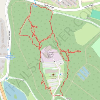
Name: Cyfarthfa Park paths trail, distance, elevation, map, profile, GPS track
Coordinates: 51.75723 -3.39356 51.76148 -3.38894
Topography: Merthyr Tydfil County Borough topographic map, elevation, terrain
Other hiking, mountain biking, running and outdoor activity trails
Click on a trail to view its statistics, map and profile.
The Headstock 500
United Kingdom > Wales > Newport > Newport
Distance: 300.4 mi • Elevation gain: 9,616 m • Maximum elevation: 691 m
Treorchy, Cearphilly, Pen y Fan
United Kingdom > Wales > Caerphilly County Borough > Tredegar
Distance: 79.1 mi • Elevation gain: 1,934 m • Maximum elevation: 501 m