Make a donation
Gear up for your next adventure:
As an Amazon Associate, this site earns from qualifying purchases at no extra cost to you.
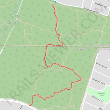
Tuart walk
- Distance: 1.3 mi
- Elevation gain: 18 m
- Maximum elevation: 35 m
- Elevation loss: 26 m
- Minimum elevation: 19 m
- Moving time: 25 m 57 s
- Moving speed: 2.9 mph
- Maximum speed: 5.2 mph
- Total time: 26 m 31 s
- Global speed: 2.9 mph
Interactive trail map
Make a donation
Gear up for your next adventure:
As an Amazon Associate, this site earns from qualifying purchases at no extra cost to you.
Trail profile
- Distance: 1.3 mi
- Elevation gain: 18 m
- Maximum elevation: 35 m
- Elevation loss: 26 m
- Minimum elevation: 19 m
- Moving time: 25 m 57 s
- Moving speed: 2.9 mph
- Maximum speed: 5.2 mph
- Total time: 26 m 31 s
- Global speed: 2.9 mph
Make a donation
Gear up for your next adventure:
As an Amazon Associate, this site earns from qualifying purchases at no extra cost to you.
About this trail
Name: Tuart walk trail, distance, elevation, map, profile, GPS track
Start: Maidment Parade, Dalyellup, Shire Of Capel, Western Australia, Australia (-33.39093 115.62310)
Coordinates: -33.39102 115.62310 -33.38197 115.62868
Make a donation
Gear up for your next adventure:
As an Amazon Associate, this site earns from qualifying purchases at no extra cost to you.
Other hiking, mountain biking, running and outdoor activity trails
Click on a trail to view its statistics, map and profile.
Bunbury MTB ride
Australia > Western Australia > Bunbury
Le Tour de Bunbury
Distance: 25.4 mi • Elevation gain: 400 m • Maximum elevation: 39 m
Tuart trails
Australia > Western Australia > Bunbury
Distance: 3.6 mi • Elevation gain: 40 m • Maximum elevation: 33 m
Tuart trails
Australia > Western Australia > Bunbury
Distance: 1.8 mi • Elevation gain: 19 m • Maximum elevation: 30 m
Tuart trails
Australia > Western Australia > Bunbury
Distance: 1.4 mi • Elevation gain: 16 m • Maximum elevation: 32 m
Make a donation
Gear up for your next adventure:
As an Amazon Associate, this site earns from qualifying purchases at no extra cost to you.