Thiruvizha
- Distance: 2.0 mi
- Elevation gain: 5 m
- Maximum elevation: 10 m
- Elevation loss: 4 m
- Minimum elevation: 7 m
- Moving time: 9 m 20 s
- Moving speed: 12.6 mph
- Maximum speed: 25.5 mph
- Total time: 10 m 38 s
- Global speed: 11.1 mph
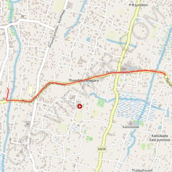
Interactive trail map
Trail profile
- Distance: 2.0 mi
- Elevation gain: 5 m
- Maximum elevation: 10 m
- Elevation loss: 4 m
- Minimum elevation: 7 m
- Moving time: 9 m 20 s
- Moving speed: 12.6 mph
- Maximum speed: 25.5 mph
- Total time: 10 m 38 s
- Global speed: 11.1 mph
About this trail
Name: Thiruvizha trail, distance, elevation, map, profile, GPS track
End: Koottuveli, Cherthala, Alappuzha, Kerala, 688555, India (9.63946 76.34009)
Coordinates: 9.63781 76.33998 9.64166 76.36003
Other hiking, mountain biking, running and outdoor activity trails
Click on a trail to view its statistics, map and profile.
Kanjikkuzhi
Distance: 1.3 mi • Elevation gain: 3 m • Maximum elevation: 10 m
Thiruvizha
Distance: 0.6 mi • Elevation gain: 2 m • Maximum elevation: 10 m