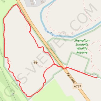
Shewalton Sandpits Wildlife Reserve (Walk)
Irvine, Scotland
- Distance: 1.0 mi
- Elevation gain: 6 m
- Maximum elevation: 11 m
- Elevation loss: 6 m
- Minimum elevation: 7 m
- Moving time: 38 m 42 s
- Moving speed: 1.5 mph
- Maximum speed: 5.5 mph
- Total time: 49 m 5 s
- Global speed: 1.2 mph
Interactive trail map
Trail profile
- Distance: 1.0 mi
- Elevation gain: 6 m
- Maximum elevation: 11 m
- Elevation loss: 6 m
- Minimum elevation: 7 m
- Moving time: 38 m 42 s
- Moving speed: 1.5 mph
- Maximum speed: 5.5 mph
- Total time: 49 m 5 s
- Global speed: 1.2 mph
About this trail
Name: Shewalton Sandpits Wildlife Reserve (Walk) trail, distance, elevation, map, profile, GPS track
Start: Shewalton Road, Irvine, North Ayrshire, Scotland, KA11 5AA, United Kingdom (55.59769 -4.65816)
End: Shewalton Road, Irvine, North Ayrshire, Scotland, KA11 5AA, United Kingdom (55.59762 -4.65751)
Coordinates: 55.59678 -4.66474 55.60083 -4.65751
Topography: North Ayrshire topographic map, elevation, terrain
Other hiking, mountain biking, running and outdoor activity trails
Click on a trail to view its statistics, map and profile.
Irvine, Scotland to Troon and back
United Kingdom > Scotland > North Ayrshire > Irvine
Evening Bike Ride
Distance: 21.0 mi • Elevation gain: 383 m • Maximum elevation: 128 m
Irvine, Scotland to Barassie Beach and back
United Kingdom > Scotland > North Ayrshire > Irvine
Bike
Distance: 13.5 mi • Elevation gain: 86 m • Maximum elevation: 15 m
Shewalton Wood Wildlife Reserve & Barassie Beach
United Kingdom > Scotland > North Ayrshire > Irvine
Bike
Distance: 16.2 mi • Elevation gain: 92 m • Maximum elevation: 18 m
Irvine, Scotland to Stonehouse and back
United Kingdom > Scotland > North Ayrshire > Irvine
Stonehouse, South Lanarkshire, Bike, Loop
Distance: 69.5 mi • Elevation gain: 1,118 m • Maximum elevation: 302 m
Irvine, Scotland to Kilmarnock and back
United Kingdom > Scotland > North Ayrshire > Irvine
Bike
Distance: 19.9 mi • Elevation gain: 192 m • Maximum elevation: 66 m
Irvine, Scotland to Greenan Castle and back
United Kingdom > Scotland > North Ayrshire > Irvine
Bike
Distance: 36.9 mi • Elevation gain: 237 m • Maximum elevation: 27 m
Irvine, Scotland to Troon and back
United Kingdom > Scotland > North Ayrshire > Irvine
Afternoon Loop Bike Ride
Distance: 20.9 mi • Elevation gain: 313 m • Maximum elevation: 129 m
Irvine, Scotland to Ayr and back
United Kingdom > Scotland > North Ayrshire > Irvine
Bike
Distance: 32.9 mi • Elevation gain: 181 m • Maximum elevation: 16 m
Irvine, Scotland to Ayr and back
United Kingdom > Scotland > North Ayrshire > Irvine
Bike
Distance: 28.7 mi • Elevation gain: 135 m • Maximum elevation: 16 m
Evening Gravel Scouting
United Kingdom > Scotland > North Ayrshire > Irvine
Distance: 14.1 mi • Elevation gain: 81 m • Maximum elevation: 19 m
Irvine Loop Bike
United Kingdom > Scotland > North Ayrshire > Irvine
Afternoon Ride
Distance: 9.0 mi • Elevation gain: 45 m • Maximum elevation: 16 m
Escort to Troon
United Kingdom > Scotland > North Ayrshire > Irvine
Bike
Distance: 21.7 mi • Elevation gain: 125 m • Maximum elevation: 19 m
Beach Gravel
United Kingdom > Scotland > North Ayrshire > Irvine
Distance: 7.6 mi • Elevation gain: 56 m • Maximum elevation: 16 m