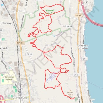
Nebo Clausland Tackamac Blauvelt
- Distance: 11.8 mi
- Elevation gain: 478 m
- Maximum elevation: 201 m
- Elevation loss: 478 m
- Minimum elevation: 73 m
- Moving time: 2 h 36 m
- Moving speed: 4.5 mph
- Maximum speed: 19.9 mph
- Total time: 2 h 52 m
- Global speed: 4.1 mph
Interactive trail map
Trail profile
- Distance: 11.8 mi
- Elevation gain: 478 m
- Maximum elevation: 201 m
- Elevation loss: 478 m
- Minimum elevation: 73 m
- Moving time: 2 h 36 m
- Moving speed: 4.5 mph
- Maximum speed: 19.9 mph
- Total time: 2 h 52 m
- Global speed: 4.1 mph
About this trail
Name: Nebo Clausland Tackamac Blauvelt trail, distance, elevation, map, profile, GPS track
Start: Orangeburg, Town of Orangetown, Rockland County, New York, 10968, United States (41.05558 -73.92737)
End: Orangeburg, Town of Orangetown, Rockland County, New York, 10968, United States (41.05559 -73.92736)
Coordinates: 41.04602 -73.94589 41.07847 -73.92461
Other hiking, mountain biking, running and outdoor activity trails
Click on a trail to view its statistics, map and profile.
Blauvelt State Park, Buttermilk Falls Park and Schuyler Town Park loop
United States > New York > Rockland County > Blauvelt
Distance: 6.0 mi • Elevation gain: 345 m • Maximum elevation: 191 m
Mount Nebo to Blauvelt State Park via Long Path Green Trail
United States > New York > Rockland County > Blauvelt
Distance: 11.8 mi • Elevation gain: 445 m • Maximum elevation: 200 m
Rail Trail Walk, Blauvelt Orangeburg
United States > New York > Rockland County > Village of Piermont
Distance: 7.9 mi • Elevation gain: 101 m • Maximum elevation: 60 m
Clausland Mountain County Park loop
United States > New York > Rockland County > Blauvelt
Distance: 4.1 mi • Elevation gain: 173 m • Maximum elevation: 200 m
Old Croton Aqueduct Trail and Bronx
United States > New York > Westchester County > Village of Croton-on-Hudson
Distance: 44.0 mi • Elevation gain: 823 m • Maximum elevation: 80 m
Blauvelt State Park
United States > New York > Rockland County > Blauvelt
Distance: 11.7 mi • Elevation gain: 434 m • Maximum elevation: 200 m