Thank you for supporting this site ❤️
Make a donation
Make a donation
Gear up for your next adventure:
As an Amazon Associate, this site earns from qualifying purchases at no extra cost to you.
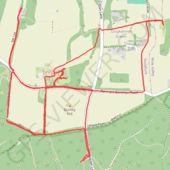
Whitedown & Dog Kennel Green loop
- Distance: 6.2 mi
- Elevation gain: 135 m
- Maximum elevation: 218 m
- Elevation loss: 130 m
- Minimum elevation: 170 m
- Moving time: 1 h 6 m
- Moving speed: 5.6 mph
- Maximum speed: 9.1 mph
- Total time: 1 h 9 m
- Global speed: 5.4 mph
Interactive trail map
Thank you for supporting this site ❤️
Make a donation
Make a donation
Gear up for your next adventure:
As an Amazon Associate, this site earns from qualifying purchases at no extra cost to you.
Trail profile
- Distance: 6.2 mi
- Elevation gain: 135 m
- Maximum elevation: 218 m
- Elevation loss: 130 m
- Minimum elevation: 170 m
- Moving time: 1 h 6 m
- Moving speed: 5.6 mph
- Maximum speed: 9.1 mph
- Total time: 1 h 9 m
- Global speed: 5.4 mph
Thank you for supporting this site ❤️
Make a donation
Make a donation
Gear up for your next adventure:
As an Amazon Associate, this site earns from qualifying purchases at no extra cost to you.
About this trail
Name: Whitedown & Dog Kennel Green loop trail, distance, elevation, map, profile, GPS track
Start: Whitedown Lane, Wotton, Mole Valley, Surrey, England, RH5 6SL, United Kingdom (51.23354 -0.40448)
Coordinates: 51.23310 -0.41447 51.24473 -0.39562
Topography: Mole Valley topographic map, elevation, terrain
Thank you for supporting this site ❤️
Make a donation
Make a donation
Gear up for your next adventure:
As an Amazon Associate, this site earns from qualifying purchases at no extra cost to you.