Thank you for supporting this site ❤️
Make a donation
Make a donation
Gear up for your next adventure:
As an Amazon Associate, this site earns from qualifying purchases at no extra cost to you.
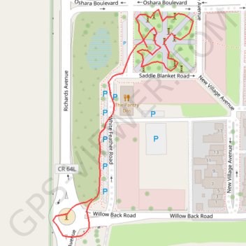
Oshara Village park sculptures
sculptures, park
- Distance: 0.4 mi
- Elevation gain: 2 m
- Maximum elevation: 2,005 m
- Elevation loss: 4 m
- Minimum elevation: 2,000 m
- Moving time: 12 m 11 s
- Moving speed: 1.9 mph
- Maximum speed: 4.3 mph
- Total time: 17 m 48 s
- Global speed: 1.3 mph
Interactive trail map
Thank you for supporting this site ❤️
Make a donation
Make a donation
Gear up for your next adventure:
As an Amazon Associate, this site earns from qualifying purchases at no extra cost to you.
Trail profile
- Distance: 0.4 mi
- Elevation gain: 2 m
- Maximum elevation: 2,005 m
- Elevation loss: 4 m
- Minimum elevation: 2,000 m
- Moving time: 12 m 11 s
- Moving speed: 1.9 mph
- Maximum speed: 4.3 mph
- Total time: 17 m 48 s
- Global speed: 1.3 mph
Thank you for supporting this site ❤️
Make a donation
Make a donation
Gear up for your next adventure:
As an Amazon Associate, this site earns from qualifying purchases at no extra cost to you.
About this trail
Name: Oshara Village park sculptures trail, distance, elevation, map, profile, GPS track
End: Richards Avenue, Santa Fe County, New Mexico, 87057, United States (35.61188 -106.00024)
Coordinates: 35.61153 -106.00068 35.61362 -105.99910
Thank you for supporting this site ❤️
Make a donation
Make a donation
Gear up for your next adventure:
As an Amazon Associate, this site earns from qualifying purchases at no extra cost to you.